Friday, June 17, 2016

Day Nine Heading to Cape Breton Island

The sun was shining this morning when we got up but it was still cool.  By the time we had breakfast and packed up to check out of our hotel, the temperature went up to 16 C.  A nice change from 8 C yesterday.  We decided to walk around down town some more because the provincial legislature is just a few blocks from our hotel. 

Part of the Provincial Legislature.

A closer look at the war memorial.

We walked around the building instead of taking the street and came across more buildings and a sign.

1864 was the year of the Charlottetown conference when there was great discussion about the provinces joining together to become Canada.

We left downtown and got on the road again.  This time we were heading for the ferry to take us back to Nova Scotia and to Cape Breton Island.

The Ferry Coming In

View from the Ferry

A lighthouse and a beach near the ferry port.  The buildings are change houses and picnic bench enclosures.  We saw them at Basin head too.

We landed in Nova Scotia and drove to Port Hawkesbury on Cape Breton Island so that we will have a good jump on the day tomorrow when we drive the Cabot Trail around the Island.

Peggy


Thursday, June 16, 2016

Day Three in Charlottetown

This morning the sun decided to shine.  We started off today driving to East Point on the Eastern side of the Island.  This is the furthest point North on the Eastern side. We were heading for the East Point Lighthouse.  


When we entered the lighthouse they said that we could climb to the top if we would like to.  So for $5 we took them up on it.  

View from the top.

There was a fishing boat out in the water.

These were the very steep stairs leading to the top.


We left East Point and when we were heading home we stopped at Basin Head Provincial Park so that we could see the beach.

The Beach

We could see a very large ship out in the water and didn't know what it was or where it was going.

The wind was really strong and it was cold, notice that I have my gloves on.

The Souris Lighthouse

As we drove into Souris we could see the ship again that we saw at Basin Head.  It was a ferry boat carrying large transport trucks and cars back and forth to Ile de Madeleine or the Magdalen  Islands.  

We watched it turn around and dock.

We then decided that it was lunch time and stopped at a cute little cafe called The Blue Fin.

Just down the road was a lobster and seafood take out that had a large parking lot right beside the ocean and the tide was going out so of course we had to walk on the ocean floor again.

It was like walking on corduroy.


I got a great picture of a mussel shell when the tide was out.

Now it was time to head back to Charlottetown.  It would take us over and hour and a half and it was now after 2 pm.  We wanted to walk around downtown and see a few of the sites there.

We found Sir John A MacDonald

The John Hamilton Grays
At the Charlottetown Conference of 1864 when confederation was being discussed there were two men called John Hamilton Gray.

We also found St Dunstan's Cathedral and the strange thing about that is that when we were children living in Toronto we went to St Dunstan's school and church.

The ice cream that is considered to be the best ice cream on the island is called Cow's.  We found the statue of "the" cow.

We enjoyed a Cow's ice cream cone even though it was freezing outside.

Tomorrow we take the ferry and head back to Nova Scotia.
Peggy


Wednesday, June 15, 2016

Day Two in Charlottetown

It was raining again today but we weren't going to let that stop us from enjoying our holiday.  We started off today checking out the quilt shop in Charlottetown.  It was hidden away in a small mall so we missed it the first time and thank goodness for the GPS, it took us through a residential area and back around again.  It was a great little shop with a few maritime fat quarters so I picked up about 10.  It was her 24th anniversary so I got a 24% discount which was really great.

We then headed for Green Gables the home of Anne of Green Gables the imaginary character from Lucy Maude Montgomery books.  Ann was there helping us enjoy our time.

Anne

It was hard for L M sometimes to forget that Anne was imaginary because she wrote about her so much.

Anne's room.
She told us that it was neat and that she made her room.

We left Green Gables and found a nice cafe for lunch.  We thought we would like to go to Cavandish Beach but it was a Provincial Park and we had to pay to go in just to see the beach so we turned around and headed for the town of O'Leary.

There was a quilt shop here and the owner was so nice.  The fabric was very reasonable and lots of PEI fabrics for my quilt. 

Lynda asked her what she thought we should see while we were in the area and she suggested a museum.

The Canadian Potato Museum.

Prince Edward Island is very famous for their potatoes.  They are the largest potato growing area in Canada.  The earth here is red and great for growing potatoes.

There is nothing like having your picture taken with the world's largest potato.

Tomorrow we will tour the Eastern side of the Island.

Peggy


Tuesday, June 14, 2016

Day Six We are off to Charlottetown

We checked out of our hotel in Truro and took the main highway heading to Charlottetown.  We noticed that just off the highway was the town of Springhill.  This is a very famous town for two reasons.  The singer Anne Murray was born in Springhill and there is a coal mine that had an explosion in 1958 killing 75 miners.  I remember hearing the news about the disaster.

We pulled off the highway and drove the 15 km to the town.  Our first stop was the Anne Murray Centre.  We went in and enjoyed Anne singing some of her popular music while we perused the exhibit.

We decided to drive on to the mine sight where there was a museum and a tour of the mine.  

We started off in the washing shed where the miners stopped off before they went home to wash the coal dust off them selves and leave their clothes so that they wouldn't take the coal dust home with them.

Each miner had his own hanger where he hung his things.

This was hanging on the wall in the washshed.

In the next shed miners got their lamps and the rest of their gear.  They carried about 30 pounds of it.  We had to put on hard hats to go down into the mine.  The ceiling was low in areas and we had to duck so we wouldn't hit our heads and the hats came in handy.

The main entrance to the mine is closed and there is a recreation center now build there but the town has opened up this entrance so that the public can go down and experience what the miners went through every day.  

The shaft has been brought up to today's safety standards so that there would be no more accidents.  Fresh air is piped in so that there is no chance of methane gas.  

We were 300 feet underground.

It was quite an experience walking down making sure we didn't bang our heads or slip on the wet ground.  The main part of the mine is now filled with water and the bodies will never be recovered.

We left Springhill after lunch and headed for the Confederation Bridge that connects Prince Edward Island to the mainland of New Brunswick.  So today we have been in 3 provinces.

The Confederation Bridge.

Once we go to the Island we decided that our next stop was a quilt shop.  It was called Bargain Fabric Shop but there weren't many bargains.  I was looking for marine fabric so that it would be from the area and it was $15 a meter, so I left it behind and hope that I can buy some at the next stop.

We found our hotel and settled in for the night and will start some sightseeing tomorrow.

Peggy


Monday, June 13, 2016

Day five Travelling to Truro

Today was a travel day.  We left the hotel in Digby and took the Evangeline trail to Windsor.  We stopped for lunch in a cute cafe called Lisa's Cafe.  We kept trying to put places along the way into the GPS because we did not want to take the express highway but wanted to to some sightseeing along the way but it decided that we wanted to take the real back roads instead of the Glooscap trail.  After a few delays we finally got on the trail and made our way to Truro.  We didn't take any pictures along the way so I thought I would post a map so that you could see how far we drove today.


The first arrow is where we started.  The circle in the middle is Windsor where we stopped for lunch and the arrow on the left is Truro.

This is just a stop over as we leave for PEI tomorrow and will be staying in Charlottetown for 3 days.  I know that there are quilt shops there so I will be stopping at a few.

Peggy

Sunday, June 12, 2016

Day Four Churches and Lighthouses

We got a bit of a late start today but it was raining so we didn't mind.  We left the town of Digby and started down the highway toward Yarmouth.  Years ago Lynda and her husband at that time purchased a piece of property in Nova Scotia so we were on a mission to try to find it after being away for about 35 years.

We turned off the highway at Weymouth and drove down back roads looking for Sissiboo Road.  After driving for about 10 minutes we found the piece of property but the people she was looking for were not home. She left and note hoping that they might call her.

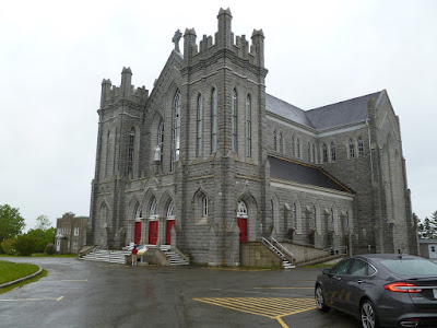
We left the main highway and took the Evangeline Trail, Highway 1 which winds down the western coast of Nova Scotia.  Our first stop was at St Bernard's church which was built from 1910 to 1942 by local people.  This area was settled by the Acadians so there is very little English in any of the write-ups about this area.

St Bernard's Church

The Main Altar.

This is a huge impressive church that you come upon around a curve.  It was raining very hard so the pictures are dark.

Our next stop was Church Point.  The Church of Sainte Marie is North America's largest wooden church.  

Sainte Marie Church

There is a huge museum is this church with many old artifacts.  It needs a lot of repairs and they are afraid that they may have to sell some of the artifacts to help pay for the repairs.

A beautiful Altar.

Further down the road we came upon the town of Saulnierville here we found Sacre-Coeur Church.  Another very impressive church.

Sacre-Coeur Church.

This church is painted yellow so it is hard to miss while driving down the road.

It was getting to be 2 pm so we needed to look for lunch.  There were no stores or restaurants on this road and then we spotted a Tim's.  Lunch at Tim's it was.

At the town of St Alphonse we found another church St Alphonse Church.  We went in and found a group of people enjoying an afternoon of singing hymns 
.  
St Alphonse Church

Inside the church is a grotto of Our Lady of Lourdes.

Our Lady of Lourdes. 

This is all hand carved.  There were also large murals on the walls painted by local artists.

Travelling down the road we came upon Cape St Mary and the Lighthouse, high on a hill overlooking the harbour.
Cape St Mary Lighthouse

Fishing Boats in the Harbour.

The tide was coming in.  
It was very foggy and raining.

We finally made our way to Yarmouth.  Since it was Sunday the quilt shops were closed and it looked like the town had "rolled up the sidewalks".  There didn't seem to be anyone in town.

We found the Information centre and asked the attendants what would be something of interest if we only had time for one thing and they directed us to the Cape Forchu Lighthouse.  We drove out to an island at the furthest end of Yarmouth.  At one point we took a wrong turn and ended up in a dead end in someones driveway.  We got straightened around and put the lighthouse into the car's GPS and seemed to drive forever but then we saw it in the fog.

Cape Forchu Lighthouse.
Also referred to as "The Beacon to Canada"

The false harbour
That is why this lighthouse was so important.

Time to make our way back to Digby so we took the main highway which was a direct route with no sightseeing.

Tomorrow we travel north to Truro and hope to be able to spend some time watching the tide come in.  Hopefully the weather will cooperate and we will drive out of the rain.

Peggy